Road Marker Views
Enter Road Address in your cars GPS: 7622 McCarthy Beach Rd, Side Lake, MN 55781 OR Enter Geographical Coordinates in your cars GPS:
Degrees Lat Long: 47.668058, -93.030757
Latitude: 47°40’05.0″N
Longitude: 93°01’50.7″W
Located in St. Louis County, off county road 5 in McCarthy Beach State Park near the Sturgeon Lake beach. Driving directions: Take route 169 north from Hibbing. Turn left onto County Road 5. Travel 15 miles, turn left onto county road 65 and follow signs to Mc Carthy Beach State Park. Once inside the park, follow signs to Beach Picnic Area on Sturgeon Lake. Turn left into the Picnic Area parking lot. Go past the recreation building to the marker, facing Sturgeon Lake.
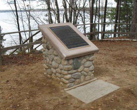
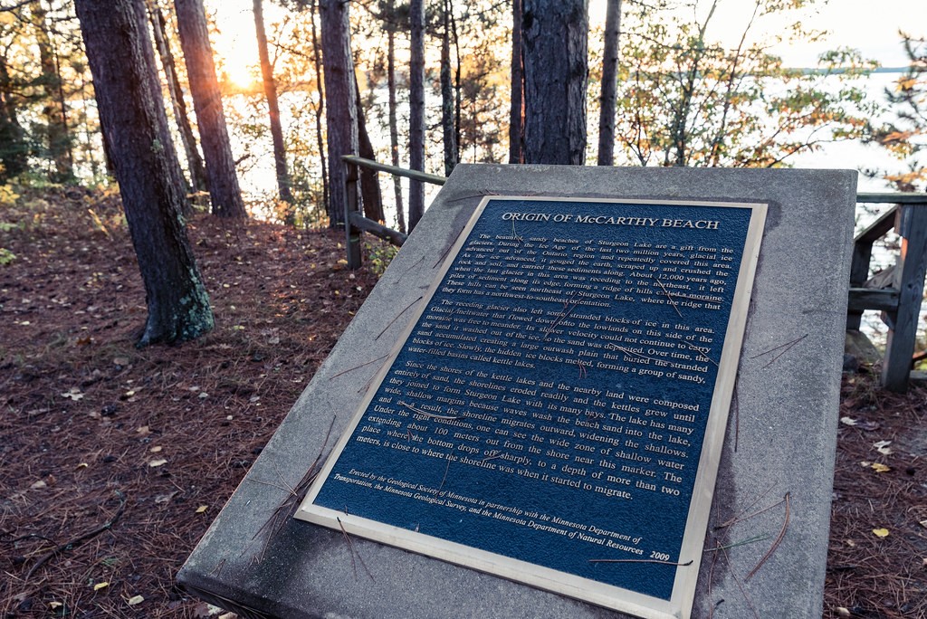
Marker Number:265 Marker Composition: Stone with Bronze plaques Text on Marker:
ORIGIN OF McCARTHY BEACH The beautiful, sandy beaches of Sturgeon Lake are a gift from the glaciers. During the Ice Age of the last two mil-lion years, glacial ice advanced out of the Ontario region and repeatedly covered this area. As the ice advanced, it gouged the earth, scraped up and crushed the rock and soil, and carried these sediments along. About 12,000 years ago, when the last glacier in this area was receding to the northeast, it left piles of sediment along its edge, forming a ridge of hills called a moraine. These hills can be seen northeast of Sturgeon Lake, where the ridge they form has a northwest-to-southeast orientation. The receding glacier also left some stranded blocks of ice in this area. Glacial meltwater that flowed down onto the lowlands on this side of the moraine was free to meander. Its slower velocity could not continue to carry the sand it washed out of the ice, so the sand was deposited. Over time, the sand accumulated creating a large outwash plain that buried the stranded blocks of ice. Slowly, the hidden ice blocks melted, forming a group of sandy, water-filled basins called kettle lakes. Since the shores of the kettle lakes and the nearby land were composed entirely of sand, the shorelines eroded readily and the kettles grew until they joined to form Sturgeon Lake with its many bays. The lake has many wide, shallow margins because waves wash the beach sand into the lake, and as a result, the shoreline migrates outward, widening the shallows. Under the right conditions, one can see the wide zone of shallow water extending about 100 meters out from the shore near this marker. The place where the bottom drops off sharply, to a depth of more than two meters, is close to where the shoreline was when it started to migrate. Erected by the Geological Society of Minnesota in partnership with the Minnesota Department of Transportation, the Minnesota Geological Survey, and the Minnesota Department of Natural Resources. 2003
Region: North Central/West Region Date Updated: 6-12-25 Information Needed:
- Marker Images
Condition of Marker: New Do it Yourself Region: Iron Range Verification: Patrick Steury
Enter Road Address in your cars GPS:
7622 McCarthy Beach Rd, Side Lake, MN 55781
OR
Enter Geographical Coordinates in your cars GPS:
Degrees Lat Long: 47.668058, -93.030757
Latitude: 47°40’05.0″N
Longitude: 93°01’50.7″W
Country: Saint Louis County
Where Found:
Located in St. Louis County, off county road 5 in McCarthy Beach State Park near the Sturgeon Lake beach. Driving directions: Take route 169 north from Hibbing. Turn left onto County Road 5. Travel 15 miles, turn left onto county road 65 and follow signs to Mc Carthy Beach State Park. Once inside the park, follow signs to Beach Picnic Area on Sturgeon Lake. Turn left into the Picnic Area parking lot. Go past the recreation building to the marker, facing Sturgeon Lake.
Marker Number: 265
Marker Composition: Stone with Bronze plaques
Text on Marker:
ORIGIN OF McCARTHY BEACH The beautiful, sandy beaches of Sturgeon Lake are a gift from the glaciers. During the Ice Age of the last two mil-lion years, glacial ice advanced out of the Ontario region and repeatedly covered this area. As the ice advanced, it gouged the earth, scraped up and crushed the rock and soil, and carried these sediments along. About 12,000 years ago, when the last glacier in this area was receding to the northeast, it left piles of sediment along its edge, forming a ridge of hills called a moraine. These hills can be seen northeast of Sturgeon Lake, where the ridge they form has a northwest-to-southeast orientation. The receding glacier also left some stranded blocks of ice in this area. Glacial meltwater that flowed down onto the lowlands on this side of the moraine was free to meander. Its slower velocity could not continue to carry the sand it washed out of the ice, so the sand was deposited. Over time, the sand accumulated creating a large outwash plain that buried the stranded blocks of ice. Slowly, the hidden ice blocks melted, forming a group of sandy, water-filled basins called kettle lakes. Since the shores of the kettle lakes and the nearby land were composed entirely of sand, the shorelines eroded readily and the kettles grew until they joined to form Sturgeon Lake with its many bays. The lake has many wide, shallow margins because waves wash the beach sand into the lake, and as a result, the shoreline migrates outward, widening the shallows. Under the right conditions, one can see the wide zone of shallow water extending about 100 meters out from the shore near this marker. The place where the bottom drops off sharply, to a depth of more than two meters, is close to where the shoreline was when it started to migrate. Erected by the Geological Society of Minnesota in partnership with the Minnesota Department of Transportation, the Minnesota Geological Survey, and the Minnesota Department of Natural Resources. 2003
Region: North Central/West Region
Date Updated: 6-12-25 Information Needed:
- Marker Images
Condition of Marker: New
Do it Yourself Region: Iron Range
Verification: Patrick Steury