Road Marker Views
Description:
Google Map panorama image of the Pothole.
The St. Croix Dalles (Home of the World’s Deepest Potholes)
Enter Road Address in your cars GPS: 307 Milltown Rd, Taylors Falls, MN 55084 OR Enter Geographical Coordinates in your cars GPS:
Degrees Lat Long: 45.399417, -92.651556
Latitude: 45°23’57.9″N
Longitude: 92°39’05.6″W
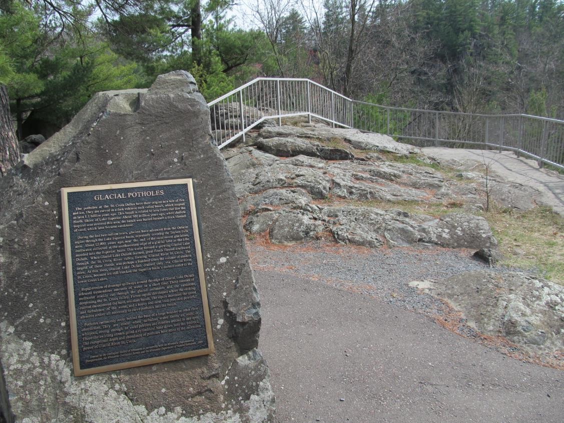
Marker is in Taylors Falls, Minnesota, in Chisago County. Marker can be reached from U.S. 8 near Bench Street. Marker is in Interstate State Park (vehicle permit required) beyond the Visitor Center.
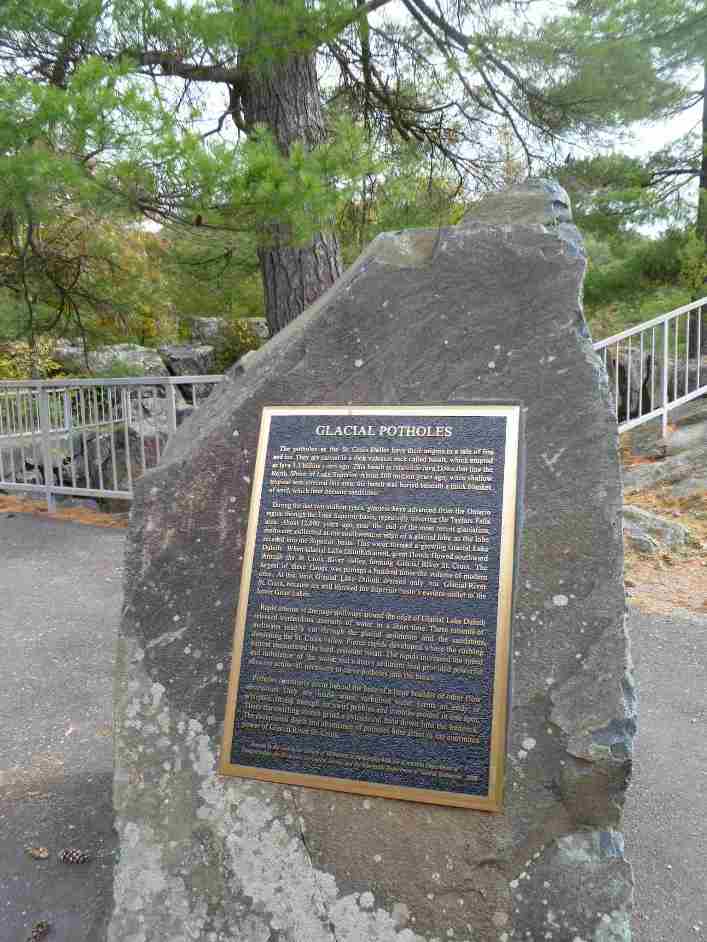
Marker Number:4 Marker Composition: Stone with Bronze plaques Text on Marker:
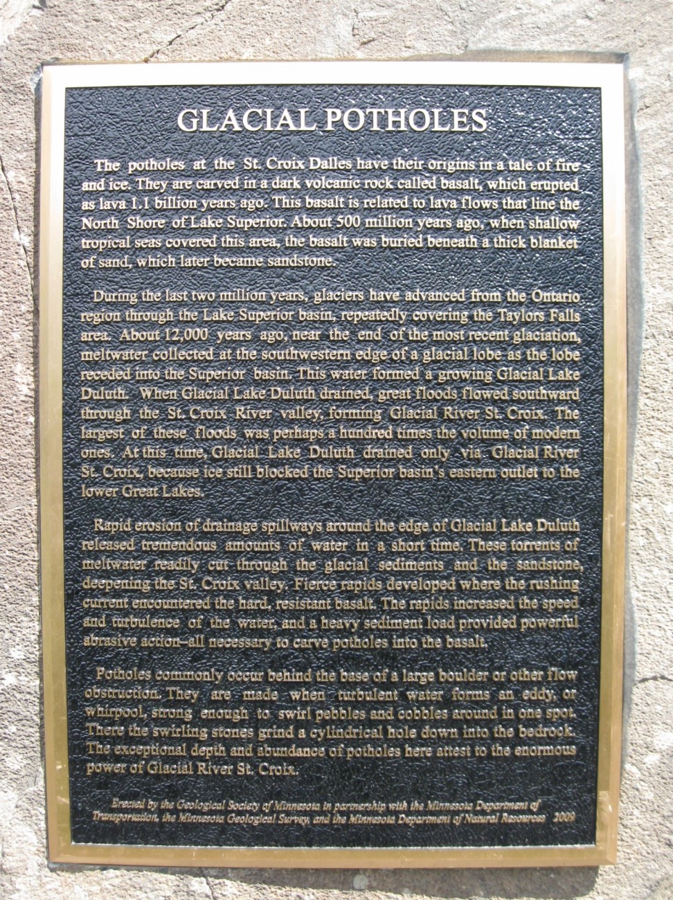
Glacial Potholes
The potholes at the St. Croix Dalles have their origins in a tale of fire and ice. They are carved in a dark volcanic rock called basalt, which erupted as lava 1.1 billion years ago. This basalt is related to lava flows that line the North Shore of Lake Superior. About 500 million years ago, when shallow tropical seas covered this area, the basalt was buried beneath a thick blanket of sand, which later became sandstone.
During the last two million years, glaciers have advanced from the Ontario region through the Lake Superior basin, repeatedly covering the Taylors Falls area. About 12,000 years ago, near the end of the most recent glaciation, meltwater collected at the southwestern edge of a glacial lobe as the lobe receded into the Superior basin. This water formed a growing Glacial Lake Duluth. When Glacial Lake Duluth drained, great floods flowed southward through the St. Croix River valley, forming Glacial River St. Croix. The largest of these floods was perhaps a hundred times the volume of modern ones. At this time, Glacial Lake Duluth drained only via Glacial River St. Croix, because ice still blocked the Superior basin’s eastern outlet to the lower Great Lakes.
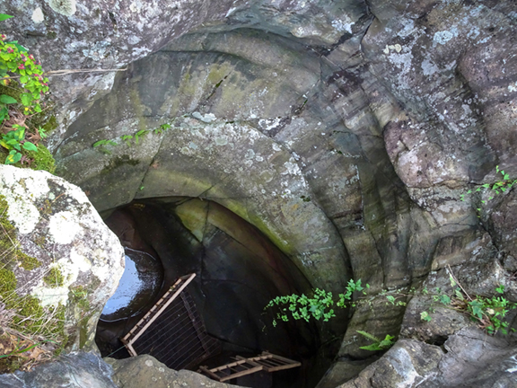
Rapid erosion of drainage spillways around the edge of Glacial Lake Duluth released tremendous amounts of water in a short time. These torrents of meltwater readily cut through the glacial sediments and the sandstone, deepening the St. Croix valley. Fierce rapids developed where the rushing current encountered the hard, resistant basalt. The rapids increased the speed and turbulence of the water, and a heavy sediment load provided powerful abrasive action—all necessary to carve potholes into the basalt.
Potholes commonly occur behind the base of a large boulder or other flow obstruction. They are made when turbulent water forms an eddy, or whirlpool, strong enough to swirl pebbles and cobbles around in one spot. There the swirling stones grind a cylindrical hole down into the bedrock. The exceptional depth and abundance of potholes here attest to the enormous power of Glacial River St. Croix.
Erected by the Geological Society of Minnesota in partnership with the Minnesota Department of Transportation, the Minnesota Geological Survey, and the Minnesota Department of Natural Resources. 2003
Region: Metro Region Date Updated: 6-12-25 Information Needed:
- Marker Images
Condition of Marker: Good Do it Yourself Region: St. Croix River Valley Verification: Patrick Steury
Description:
Google Map panorama image of the Pothole.
The St. Croix Dalles (Home of the World’s Deepest Potholes)
Enter Road Address in your cars GPS:
307 Milltown Rd, Taylors Falls, MN 55084
OR
Enter Geographical Coordinates in your cars GPS:
Degrees Lat Long: 45.399417, -92.651556
Latitude: 45°23’57.9″N
Longitude: 92°39’05.6″W
Country: Chisago County
Where Found:
Marker is in Taylors Falls, Minnesota, in Chisago County. Marker can be reached from U.S. 8 near Bench Street. Marker is in Interstate State Park (vehicle permit required) beyond the Visitor Center.
Marker Number: 4
Marker Composition: Stone with Bronze plaques
Text on Marker:
Glacial Potholes
The potholes at the St. Croix Dalles have their origins in a tale of fire and ice. They are carved in a dark volcanic rock called basalt, which erupted as lava 1.1 billion years ago. This basalt is related to lava flows that line the North Shore of Lake Superior. About 500 million years ago, when shallow tropical seas covered this area, the basalt was buried beneath a thick blanket of sand, which later became sandstone.
During the last two million years, glaciers have advanced from the Ontario region through the Lake Superior basin, repeatedly covering the Taylors Falls area. About 12,000 years ago, near the end of the most recent glaciation, meltwater collected at the southwestern edge of a glacial lobe as the lobe receded into the Superior basin. This water formed a growing Glacial Lake Duluth. When Glacial Lake Duluth drained, great floods flowed southward through the St. Croix River valley, forming Glacial River St. Croix. The largest of these floods was perhaps a hundred times the volume of modern ones. At this time, Glacial Lake Duluth drained only via Glacial River St. Croix, because ice still blocked the Superior basin’s eastern outlet to the lower Great Lakes.
Rapid erosion of drainage spillways around the edge of Glacial Lake Duluth released tremendous amounts of water in a short time. These torrents of meltwater readily cut through the glacial sediments and the sandstone, deepening the St. Croix valley. Fierce rapids developed where the rushing current encountered the hard, resistant basalt. The rapids increased the speed and turbulence of the water, and a heavy sediment load provided powerful abrasive action—all necessary to carve potholes into the basalt.
Potholes commonly occur behind the base of a large boulder or other flow obstruction. They are made when turbulent water forms an eddy, or whirlpool, strong enough to swirl pebbles and cobbles around in one spot. There the swirling stones grind a cylindrical hole down into the bedrock. The exceptional depth and abundance of potholes here attest to the enormous power of Glacial River St. Croix.
Erected by the Geological Society of Minnesota in partnership with the Minnesota Department of Transportation, the Minnesota Geological Survey, and the Minnesota Department of Natural Resources. 2003
Region: Metro Region
Date Updated: 6-12-25 Information Needed:
- Marker Images
Condition of Marker: Good
Do it Yourself Region: St. Croix River Valley
Verification: Patrick Steury