Road Marker Views
Enter Road Address in your cars GPS: 8525 W Skyline Pkwy, Duluth, MN 55810 OR Enter Geographical Coordinates in your cars GPS:
Degrees Lat Long : 46.729374, -92.205055
Latitude: 46°43’48.7″N
Longitude: 92°12’21.8″W

Marker is near Proctor, Minnesota, in Saint Louis County. It is in West Duluth. Marker can be reached from Interstate 35 at milepost 249, on the left when traveling north. Marker is in a rest area accessible from Interstate 35.
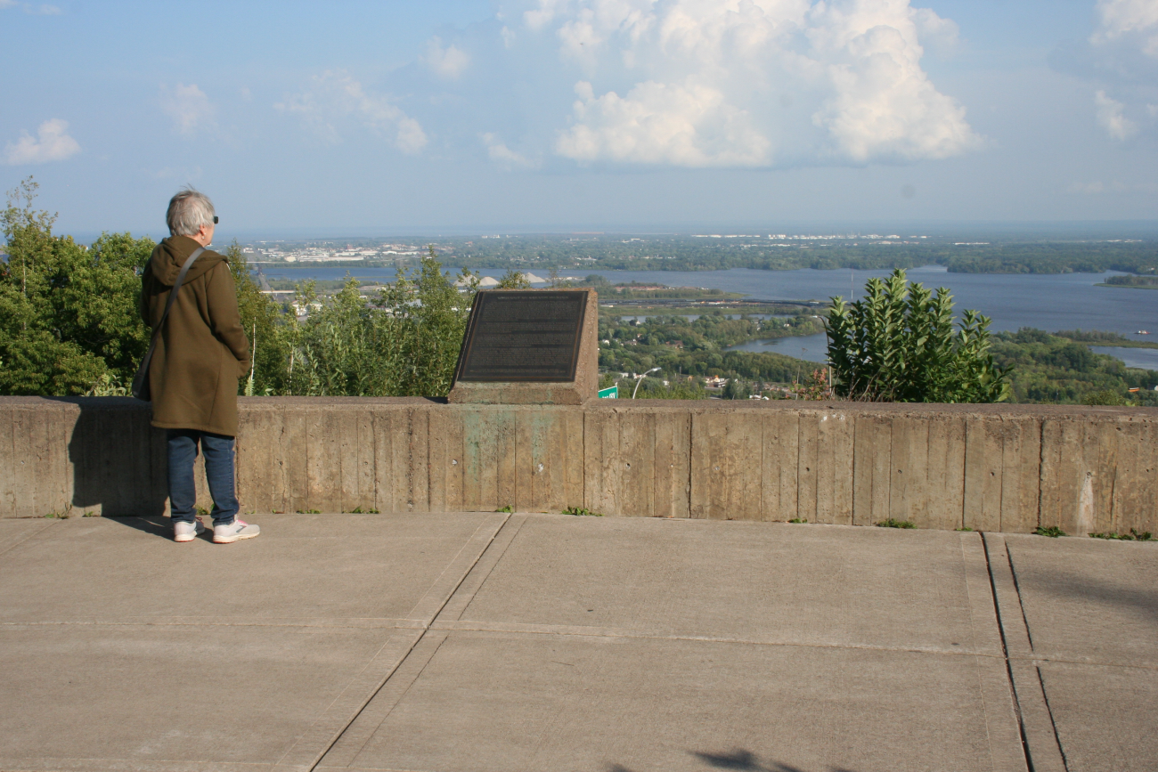
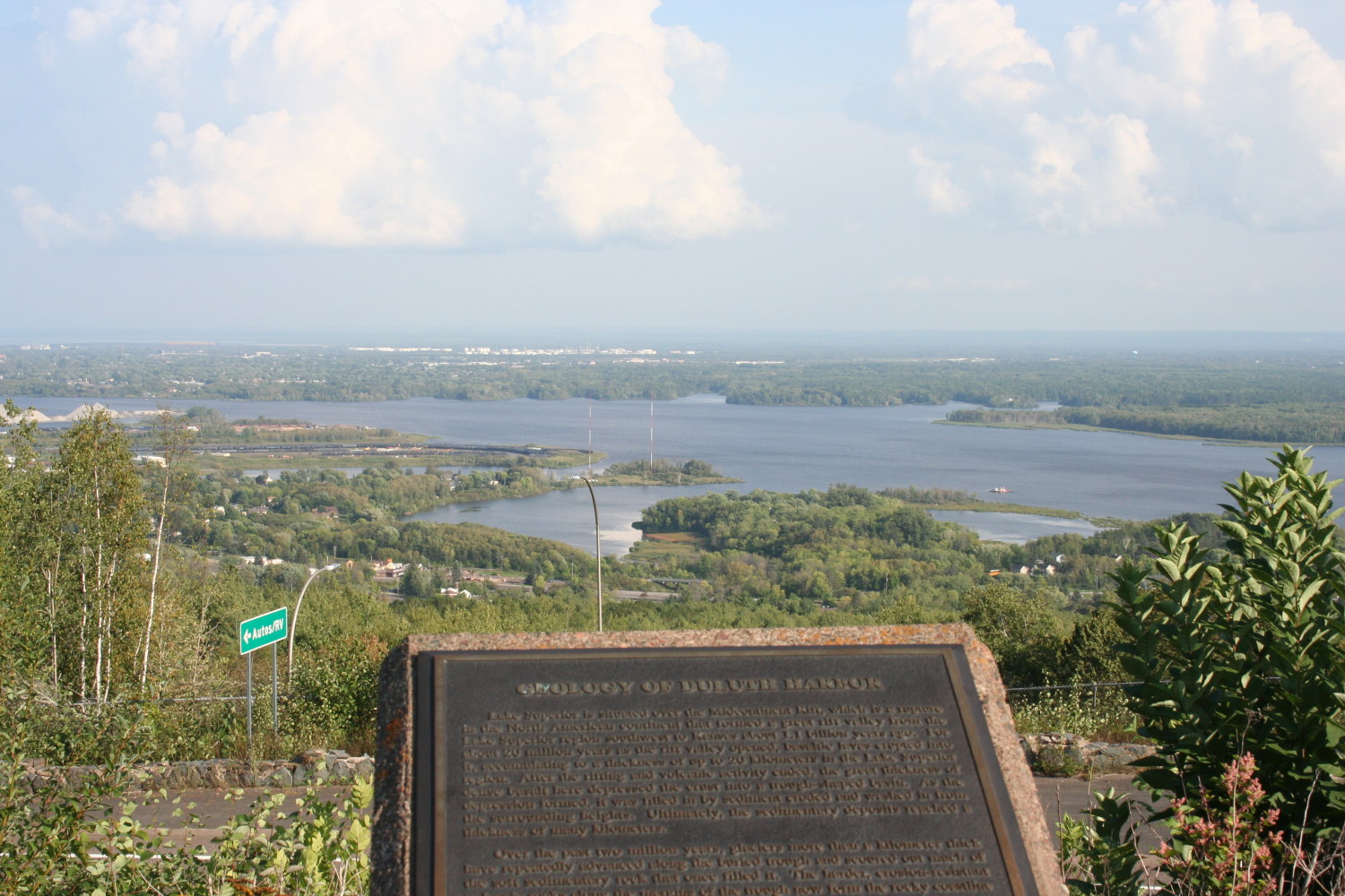
Marker Number:247 Marker Composition: Stone with Bronze plaques Text on Marker:
GEOLOGY OF DULUTH HARBOR Lake Superior is situated over the Midcontinent Rift, which is a rupture in the North American continent that formed a great rift valley from the Lake Superior region southwest to Kansas about 1.1 billion years ago. For about 20 million years as the rift valley opened, basaltic lavas erupted into it, accumulating to a thickness of up to 20 kilometers in the Lake Superior region. After the rifting and volcanic activity ended, the great thickness of dense basalt here depressed the crust into a trough-shaped basin. As the depression formed, it was filled in by sediment eroded and washed in from the surrounding heights. Ultimately, the sedimentary deposits reached a thickness of many kilometers. Over the past two million years, glaciers more than a kilometer thick have repeatedly advanced along the buried trough and scoured out much of the soft sedimentary rock that once filled it. The harder, erosion-resistant volcanic rocks along the margins of the trough now form the rocky coastline of much of Lake Superior. Ten thousand years ago, as the glacial ice in the basin melted west to east, water ponded in front of the ice almost to the level of this marker to form Glacial Lake Duluth. Eventually, the ice melted out of the eastern lake basin and a drainage way opened to the lower Great Lakes. When the eastern outlet first formed, it was lower in elevation than today and drained the lake to 60 meters below its present level. Relieved of the great weight of this glacial ice, the earth’s crust has been slowly rising. The rate of rebound is fastest where the load of ice has been most recently removed. Thus, the northeastern lake basin and its eastern outlet are rising faster, thereby tilting the basin toward the southwest and flooding the mouth of the St. Louis River. Duluth harbor, which was formed by this submergence, has been enlarged by the formation of Minnesota Point, a baymouth bar sand deposit washed there by easterly waves and shore currents transporting beach sand from Wisconsin. Erected by the Geological Society of Minnesota in partnership with the Minnesota Department of Transportation and the Minnesota Geological Survey. 1998
Region: Northeast Region Date Updated: 6-12-25 Information Needed:
- Marker Images
Condition of Marker: Good Do it Yourself Region: North Shore Verification: Patrick Steury
Enter Road Address in your cars GPS:
8525 W Skyline Pkwy, Duluth, MN 55810
OR
Enter Geographical Coordinates in your cars GPS:
Degrees Lat Long : 46.729374, -92.205055
Latitude: 46°43’48.7″N
Longitude: 92°12’21.8″W
Country: Saint Louis County
Where Found:
Marker is near Proctor, Minnesota, in Saint Louis County. It is in West Duluth. Marker can be reached from Interstate 35 at milepost 249, on the left when traveling north. Marker is in a rest area accessible from Interstate 35.
Marker Number: 247
Marker Composition: Stone with Bronze plaques
Text on Marker:
GEOLOGY OF DULUTH HARBOR Lake Superior is situated over the Midcontinent Rift, which is a rupture in the North American continent that formed a great rift valley from the Lake Superior region southwest to Kansas about 1.1 billion years ago. For about 20 million years as the rift valley opened, basaltic lavas erupted into it, accumulating to a thickness of up to 20 kilometers in the Lake Superior region. After the rifting and volcanic activity ended, the great thickness of dense basalt here depressed the crust into a trough-shaped basin. As the depression formed, it was filled in by sediment eroded and washed in from the surrounding heights. Ultimately, the sedimentary deposits reached a thickness of many kilometers. Over the past two million years, glaciers more than a kilometer thick have repeatedly advanced along the buried trough and scoured out much of the soft sedimentary rock that once filled it. The harder, erosion-resistant volcanic rocks along the margins of the trough now form the rocky coastline of much of Lake Superior. Ten thousand years ago, as the glacial ice in the basin melted west to east, water ponded in front of the ice almost to the level of this marker to form Glacial Lake Duluth. Eventually, the ice melted out of the eastern lake basin and a drainage way opened to the lower Great Lakes. When the eastern outlet first formed, it was lower in elevation than today and drained the lake to 60 meters below its present level. Relieved of the great weight of this glacial ice, the earth’s crust has been slowly rising. The rate of rebound is fastest where the load of ice has been most recently removed. Thus, the northeastern lake basin and its eastern outlet are rising faster, thereby tilting the basin toward the southwest and flooding the mouth of the St. Louis River. Duluth harbor, which was formed by this submergence, has been enlarged by the formation of Minnesota Point, a baymouth bar sand deposit washed there by easterly waves and shore currents transporting beach sand from Wisconsin. Erected by the Geological Society of Minnesota in partnership with the Minnesota Department of Transportation and the Minnesota Geological Survey. 1998
Region: Northeast Region
Date Updated: 6-12-25 Information Needed:
- Marker Images
Condition of Marker: Good
Do it Yourself Region: North Shore
Verification: Patrick Steury