Road Marker Views
Description:
Link to Beaver Creek Valley State Park.
Enter Road Address in your cars GPS: 15954 County Rd 1, Caledonia, MN 55921 OR Enter Geographical Coordinates in your cars GPS:
Degrees Lat Long: 43.639830, -91.575911
Latitude: 43°38’27.5″N
Longitude: 91°34’40.5″W
Located in Houston County, 5 miles W of Caledonia on county road 1, in Beaver Creek Valley State Park near Big Spring.
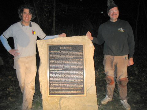
Marker Number:66 Marker Composition: Stone with Bronze plaques Text on Marker:
Beaver Creek Valley State Park- Big Spring
BIG SPRING
Water bubbling out of the ground is a natural wonder. Where does it come from? How long has it been in the ground? To ponder these questions can be almost routine in southeastern Minnesota. Much of this area consists of karst terrain, characterized by sinkholes, underground passageways, caves, and springs. These features are formed by surface water that enters fractures in the underlying carbonate bedrock—limestone and dolostone.
Surface water is slightly acidic from absorbing carbon dioxide in the atmosphere and soil. As this water seeps into and follows fractures in the bedrock, it slowly dissolves the carbonate rock and gradually enlarges the cracks. Continued erosion along these passageways develops a system of underground drainage that bypasses the surface drainage pattern. As a result, groundwater can move quickly to replenish an underground reservoir, and then, as is the case at Big Spring, escape through porous rock layers to finally emerge as a bubbling spring.
The water of Big Spring maintains a nearly constant temperature of about 10 degrees Celsius (50 degrees Fahrenheit). This constant temperature keeps the spring from freezing and helps sustain a healthy trout population. The mineral-rich water is also ideal for watercress—the green plants with small oval leaflets floating in the creek. These plants display tiny white flowers in summer. Watercress typically grows around springs, where the water is rich in calcium and magnesium dissolved from the underlying bedrock. Its presence is a good indicator that a stream is fed by groundwater. These bright green plants flourish year-round, adding vibrant color to even the winter scene.
The water coming from Big Spring has not been in the ground for a very long time—most likely less than a year. But this reliable source of refreshing spring water has made the valley an ideal setting for people from prehistoric Native Americans, to early European settlers, to the park visitors of today.
Erected by the Geological Society of Minnesota in partnership with the Minnesota Department of
Transportation, the Minnesota Geological Survey, and the Minnesota Department of Natural Resources 2003
Region: Southeastern Region Date Updated: 6-12-25 Information Needed:
- Marker Images
Condition of Marker: Good Do it Yourself Region: Karst Country – Southeast Corner Verification: Patrick Steury
Description:
Link to Beaver Creek Valley State Park.
Enter Road Address in your cars GPS:
15954 County Rd 1, Caledonia, MN 55921
OR
Enter Geographical Coordinates in your cars GPS:
Degrees Lat Long: 43.639830, -91.575911
Latitude: 43°38’27.5″N
Longitude: 91°34’40.5″W
Country: Houston County
Where Found:
Located in Houston County, 5 miles W of Caledonia on county road 1, in Beaver Creek Valley State Park near Big Spring.
Marker Number: 66
Marker Composition: Stone with Bronze plaques
Text on Marker:
Beaver Creek Valley State Park- Big Spring
BIG SPRING
Water bubbling out of the ground is a natural wonder. Where does it come from? How long has it been in the ground? To ponder these questions can be almost routine in southeastern Minnesota. Much of this area consists of karst terrain, characterized by sinkholes, underground passageways, caves, and springs. These features are formed by surface water that enters fractures in the underlying carbonate bedrock—limestone and dolostone.
Surface water is slightly acidic from absorbing carbon dioxide in the atmosphere and soil. As this water seeps into and follows fractures in the bedrock, it slowly dissolves the carbonate rock and gradually enlarges the cracks. Continued erosion along these passageways develops a system of underground drainage that bypasses the surface drainage pattern. As a result, groundwater can move quickly to replenish an underground reservoir, and then, as is the case at Big Spring, escape through porous rock layers to finally emerge as a bubbling spring.
The water of Big Spring maintains a nearly constant temperature of about 10 degrees Celsius (50 degrees Fahrenheit). This constant temperature keeps the spring from freezing and helps sustain a healthy trout population. The mineral-rich water is also ideal for watercress—the green plants with small oval leaflets floating in the creek. These plants display tiny white flowers in summer. Watercress typically grows around springs, where the water is rich in calcium and magnesium dissolved from the underlying bedrock. Its presence is a good indicator that a stream is fed by groundwater. These bright green plants flourish year-round, adding vibrant color to even the winter scene.
The water coming from Big Spring has not been in the ground for a very long time—most likely less than a year. But this reliable source of refreshing spring water has made the valley an ideal setting for people from prehistoric Native Americans, to early European settlers, to the park visitors of today.
Erected by the Geological Society of Minnesota in partnership with the Minnesota Department of
Transportation, the Minnesota Geological Survey, and the Minnesota Department of Natural Resources 2003
Region: Southeastern Region
Date Updated: 6-12-25 Information Needed:
- Marker Images
Condition of Marker: Good
Do it Yourself Region: Karst Country – Southeast Corner
Verification: Patrick Steury