Road Marker Views
Enter Road Address in your cars GPS: 6299 Peabody Ave N Lookout Trail OR Enter Geographical Coordinates in your cars GPS:
Degrees Lat Long: 45.0405770°, -092.7959870°
Latitude: 43°38’19.39″N
Longitude: 116°14’28.86″W
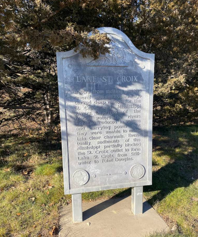
Lake St. Croix Overlook
Marker Number: Marker Composition: Text on Marker:
LAKE ST. CROIX
Waters from melting glaciers several thousand years ago carved deep valleys for the St. Croix and Mississippi Rivers. Deprived of the glacial waters the rivers were so reduced in volume and carrying power that they were unable to maintain clear channels. Eventually sediments of the Mississippi partially blocked the St. Croix outlet to form Lake St. Croix from Stillwater to Point Douglas.
Minnesota Department of Highways & Minnesota Historical Society
Region: Metro Region Information Needed:
- Marker Images
Condition of Marker: New Do it Yourself Region: St. Croix River Valley
Enter Road Address in your cars GPS:
6299 Peabody Ave N Lookout Trail
OR
Enter Geographical Coordinates in your cars GPS:
Degrees Lat Long: 45.0405770°, -092.7959870°
Latitude: 43°38’19.39″N
Longitude: 116°14’28.86″W
Country: Washington County
Where Found:
Lake St. Croix Overlook
Marker Number:
Marker Composition:
Text on Marker:
LAKE ST. CROIX
Waters from melting glaciers several thousand years ago carved deep valleys for the St. Croix and Mississippi Rivers. Deprived of the glacial waters the rivers were so reduced in volume and carrying power that they were unable to maintain clear channels. Eventually sediments of the Mississippi partially blocked the St. Croix outlet to form Lake St. Croix from Stillwater to Point Douglas.
Minnesota Department of Highways & Minnesota Historical Society
Region: Metro Region
Information Needed:
- Marker Images
Condition of Marker: New
Do it Yourself Region: St. Croix River Valley