Road Marker Views
Description:
Enter Road Address in your cars GPS: St Croix River, Stillwater, MN 55082 OR Enter Geographical Coordinates in your cars GPS:
Degrees Lat Long : 45.081361, -92.791056
Latitude: 45°04’55.2″N
Longitude 92°47’25.8″W

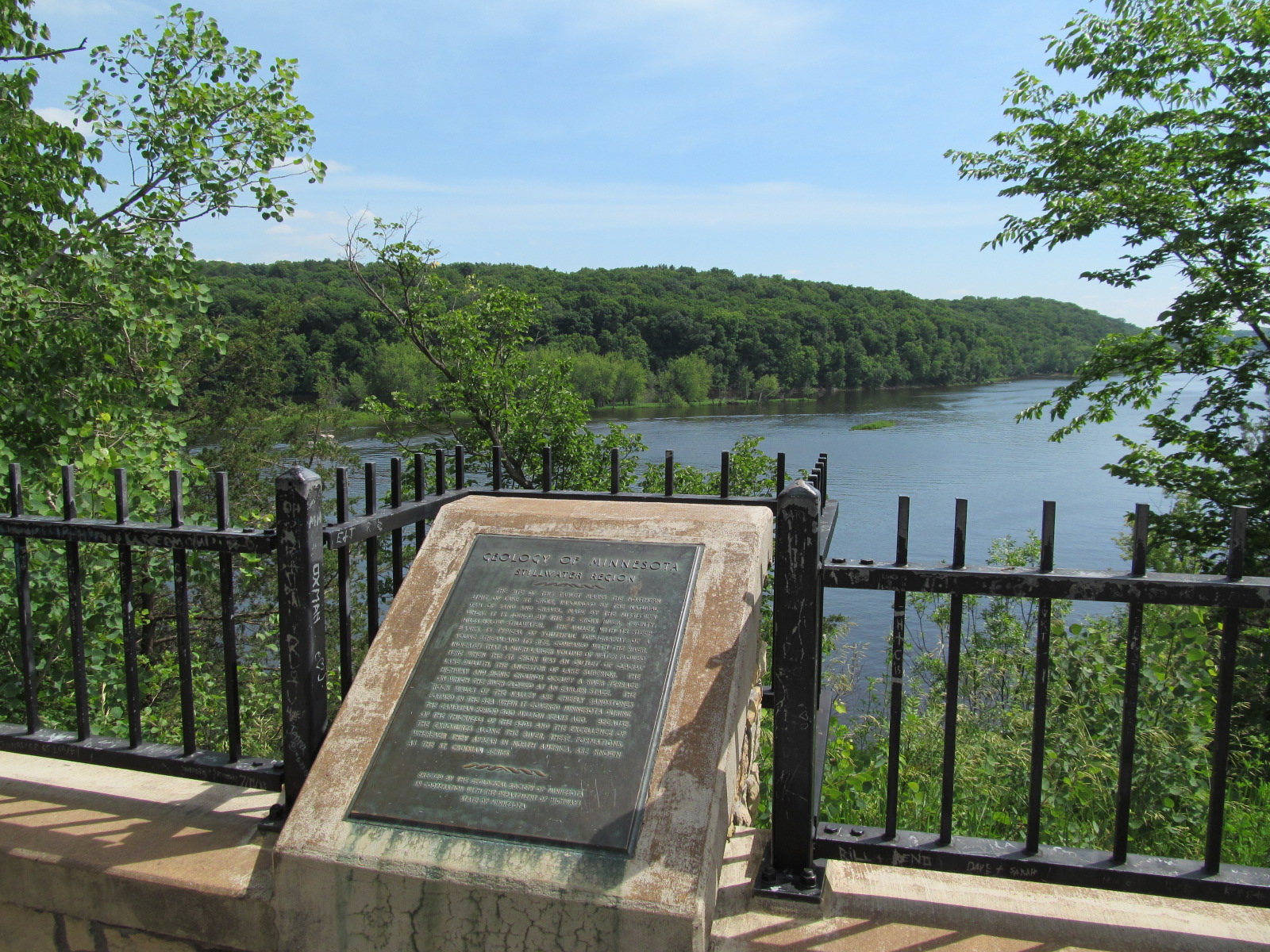
Located on state highway 95, in a wayside park 1 mile north of state highway 96 Directions: Travel north on Route 95 out of Stillwater. After the junction of Highways 95 and 96, continue about 1 mile north. Take the next right after the Boom Site Marina (private). There is a road sign indicating Scenic Overlook, Geological Marker . Pull into the parking area. Marker is situated at the overlook, looking south over the St. Croix River.
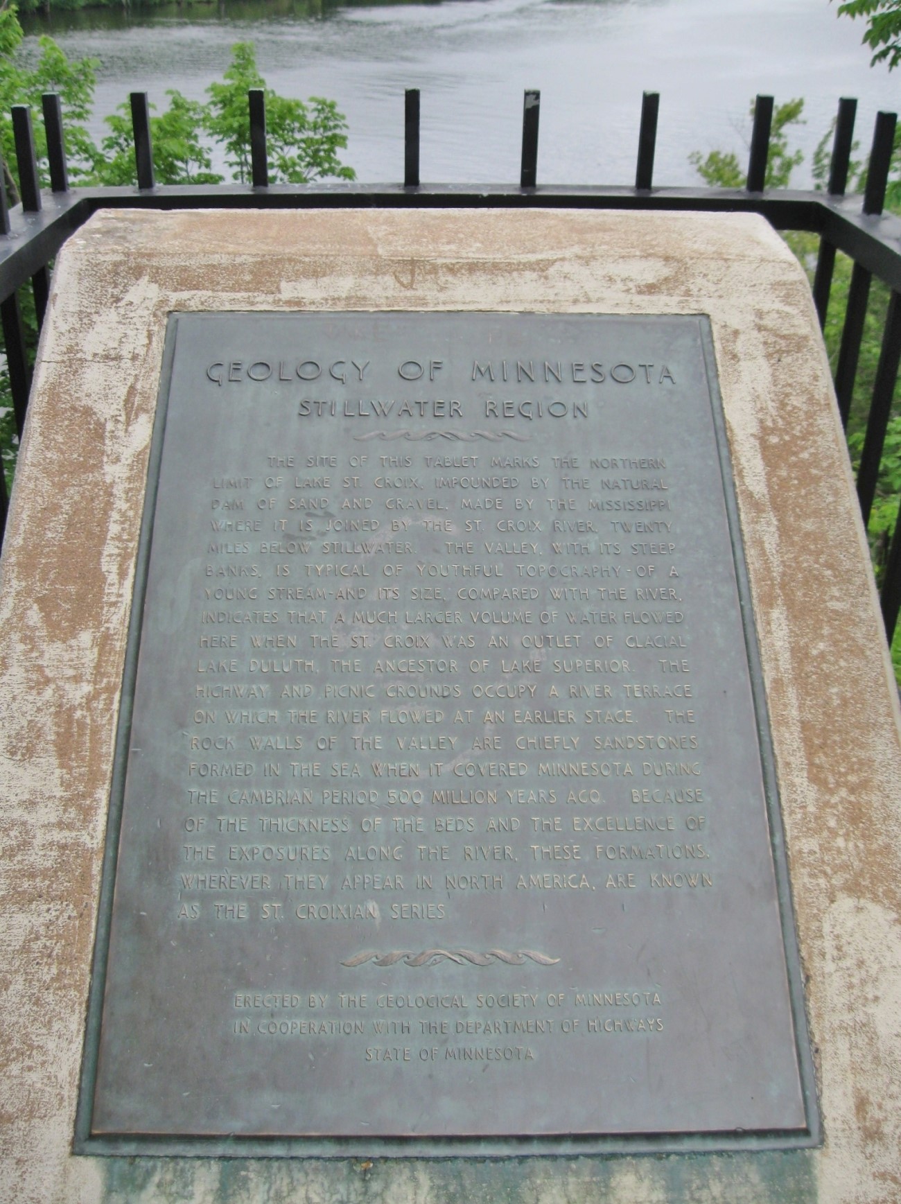
Marker Number:49 Marker Composition: Stone with Bronze plaques Text on Marker:
STILLWATER REGION
The site of this tablet marks the northern limit of Lake St. Croix, impounded by the natural dam of sand and gravel, made by the Mississippi where it is joined by the St. Croix River, twenty miles below Stillwater. The valley, with its steep banks, is typical of youthful topography—of a young stream—and its size, compared with the river, indicates that a much larger volume of water flowed here when the St. Croix was an outlet of Glacial Lake Duluth, the ancestor of Lake Superior. The highway and picnic grounds occupy a river terrace on which the river flowed at an earlier stage. The rock walls of the valley are chiefly sandstone formed in the sea when it covered Minnesota during the Cambrian period 500 million years ago. Because of the thickness of the beds and the excellence of the exposures along the river, these formations, wherever they appear in North America, are known as the St. Croixian series.
Erected by the Geological Society of Minnesota in cooperation with the Department of Highways, State of Minnesota. 1950
Region: Metro Region Date Updated: 6-12-25 Information Needed:
- Marker Images
Condition of Marker: Good Do it Yourself Region: St. Croix River Valley Verification: Patrick Steury
Description:
Enter Road Address in your cars GPS:
St Croix River, Stillwater, MN 55082
OR
Enter Geographical Coordinates in your cars GPS:
Degrees Lat Long : 45.081361, -92.791056
Latitude: 45°04’55.2″N
Longitude 92°47’25.8″W
Country: Washington County
Where Found:
Located on state highway 95, in a wayside park 1 mile north of state highway 96 Directions: Travel north on Route 95 out of Stillwater. After the junction of Highways 95 and 96, continue about 1 mile north. Take the next right after the Boom Site Marina (private). There is a road sign indicating Scenic Overlook, Geological Marker . Pull into the parking area. Marker is situated at the overlook, looking south over the St. Croix River.
Marker Number: 49
Marker Composition: Stone with Bronze plaques
Text on Marker:
STILLWATER REGION
The site of this tablet marks the northern limit of Lake St. Croix, impounded by the natural dam of sand and gravel, made by the Mississippi where it is joined by the St. Croix River, twenty miles below Stillwater. The valley, with its steep banks, is typical of youthful topography—of a young stream—and its size, compared with the river, indicates that a much larger volume of water flowed here when the St. Croix was an outlet of Glacial Lake Duluth, the ancestor of Lake Superior. The highway and picnic grounds occupy a river terrace on which the river flowed at an earlier stage. The rock walls of the valley are chiefly sandstone formed in the sea when it covered Minnesota during the Cambrian period 500 million years ago. Because of the thickness of the beds and the excellence of the exposures along the river, these formations, wherever they appear in North America, are known as the St. Croixian series.
Erected by the Geological Society of Minnesota in cooperation with the Department of Highways, State of Minnesota. 1950
Region: Metro Region
Date Updated: 6-12-25 Information Needed:
- Marker Images
Condition of Marker: Good
Do it Yourself Region: St. Croix River Valley
Verification: Patrick Steury