Road Marker Views
Description:
Enter Road Address in your cars GPS: 4801 S Minnehaha Dr, Minneapolis, MN 55417 OR Enter Geographical Coordinates in your cars GPS:
Degrees Lat Long : 44.915361, -93.209639
Latitude: 44°54’55.3″N
Longitude: 93°12’34.7″W
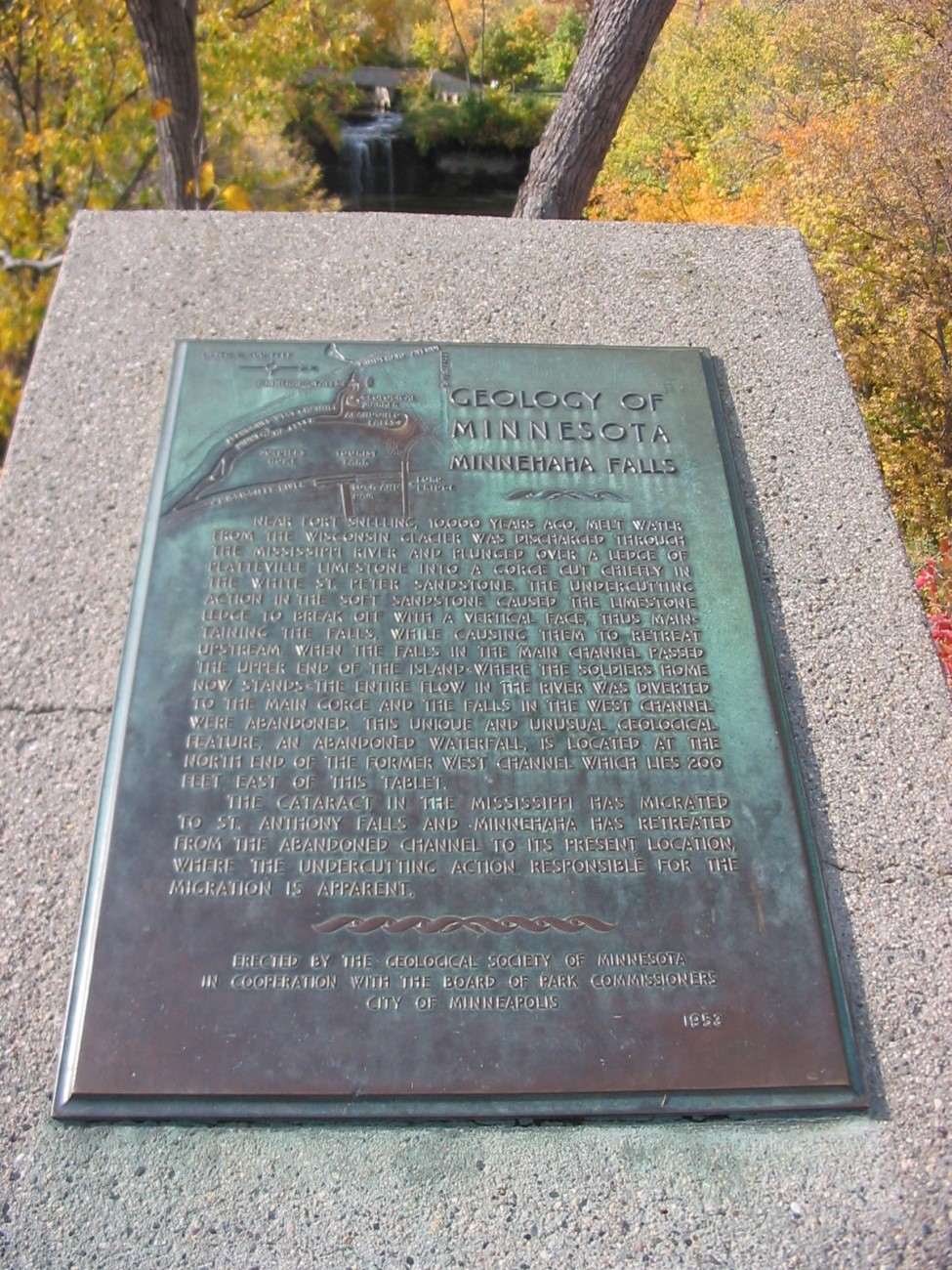
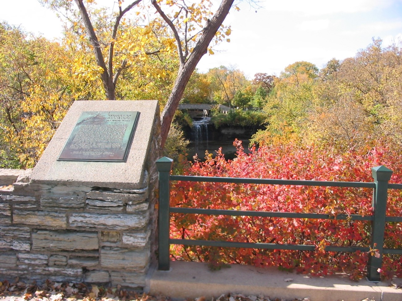
Marker is in Minneapolis, Minnesota, in Hennepin County. It is in Hiawatha. Marker can be reached from South Minnehaha Park Drive near Godfrey Road. Marker is in Minnehaha Park.
Marker Number:24 Marker Composition: Stone with Bronze plaques Text on Marker:
MINNEHAHA FALLS
Near Fort Snelling, 10,000 years ago, melt water from the Wisconsin glacier was discharged through the Mississippi River and plunged over a ledge of Platteville limestone into a gorge cut chiefly in the white St. Peter sandstone. The undercutting action in the soft sandstone caused the limestone ledge to break off with a vertical face, thus maintaining the falls, while causing them to retreat upstream. When the falls in the main channel passed the upper end of the island—where the Soldiers Home now stands—the entire flow in the river was diverted to the main gorge and the falls in the west channel were abandoned. This unique and unusual geological feature, an abandoned waterfall, is located at the north end of the former west channel which lies 200 feet east of this tablet.
The cataract in the Mississippi has migrated to St. Anthony Falls and Minnehaha has retreated from the abandoned channel to its present location, where the undercutting action responsible for the migration is apparent.
Erected by the Geological Society of Minnesota in cooperation with the Board of Park Commissioners City of Minneapolis. 1953
Region: Metro Region Date Updated: 6-12-25 Information Needed:
- Marker Images
Condition of Marker: Good Do it Yourself Region: Metro Area Verification: Patrick Steury
Description:
Enter Road Address in your cars GPS:
4801 S Minnehaha Dr, Minneapolis, MN 55417
OR
Enter Geographical Coordinates in your cars GPS:
Degrees Lat Long : 44.915361, -93.209639
Latitude: 44°54’55.3″N
Longitude: 93°12’34.7″W
Country: Hennepin County
Where Found:
Marker is in Minneapolis, Minnesota, in Hennepin County. It is in Hiawatha. Marker can be reached from South Minnehaha Park Drive near Godfrey Road. Marker is in Minnehaha Park.
Marker Number: 24
Marker Composition: Stone with Bronze plaques
Text on Marker:
MINNEHAHA FALLS
Near Fort Snelling, 10,000 years ago, melt water from the Wisconsin glacier was discharged through the Mississippi River and plunged over a ledge of Platteville limestone into a gorge cut chiefly in the white St. Peter sandstone. The undercutting action in the soft sandstone caused the limestone ledge to break off with a vertical face, thus maintaining the falls, while causing them to retreat upstream. When the falls in the main channel passed the upper end of the island—where the Soldiers Home now stands—the entire flow in the river was diverted to the main gorge and the falls in the west channel were abandoned. This unique and unusual geological feature, an abandoned waterfall, is located at the north end of the former west channel which lies 200 feet east of this tablet.
The cataract in the Mississippi has migrated to St. Anthony Falls and Minnehaha has retreated from the abandoned channel to its present location, where the undercutting action responsible for the migration is apparent.
Erected by the Geological Society of Minnesota in cooperation with the Board of Park Commissioners City of Minneapolis. 1953
Region: Metro Region
Date Updated: 6-12-25 Information Needed:
- Marker Images
Condition of Marker: Good
Do it Yourself Region: Metro Area
Verification: Patrick Steury