Road Marker Views
Enter Road Address in your cars GPS: 43749 120th St, Clitherall, MN 56524 OR Enter Geographical Coordinates in your cars GPS:
Degrees Lat Long: 46.137776, -95.577875
Latitude: 46°08’11.2″N
Longitude: 95°34’33.3″W
Marker is in Brandon, Minnesota, in Otter Tail County. Marker can be reached from 120th Street (County Highway 38) north of 435th Avenue when traveling east. Marker is located within Inspiration Peak State Wayside Park, near the north end of the parking lot, just north of 120th Avenue
Marker Number:318 Marker Composition: High Pressure Laminate Signs Text on Marker:
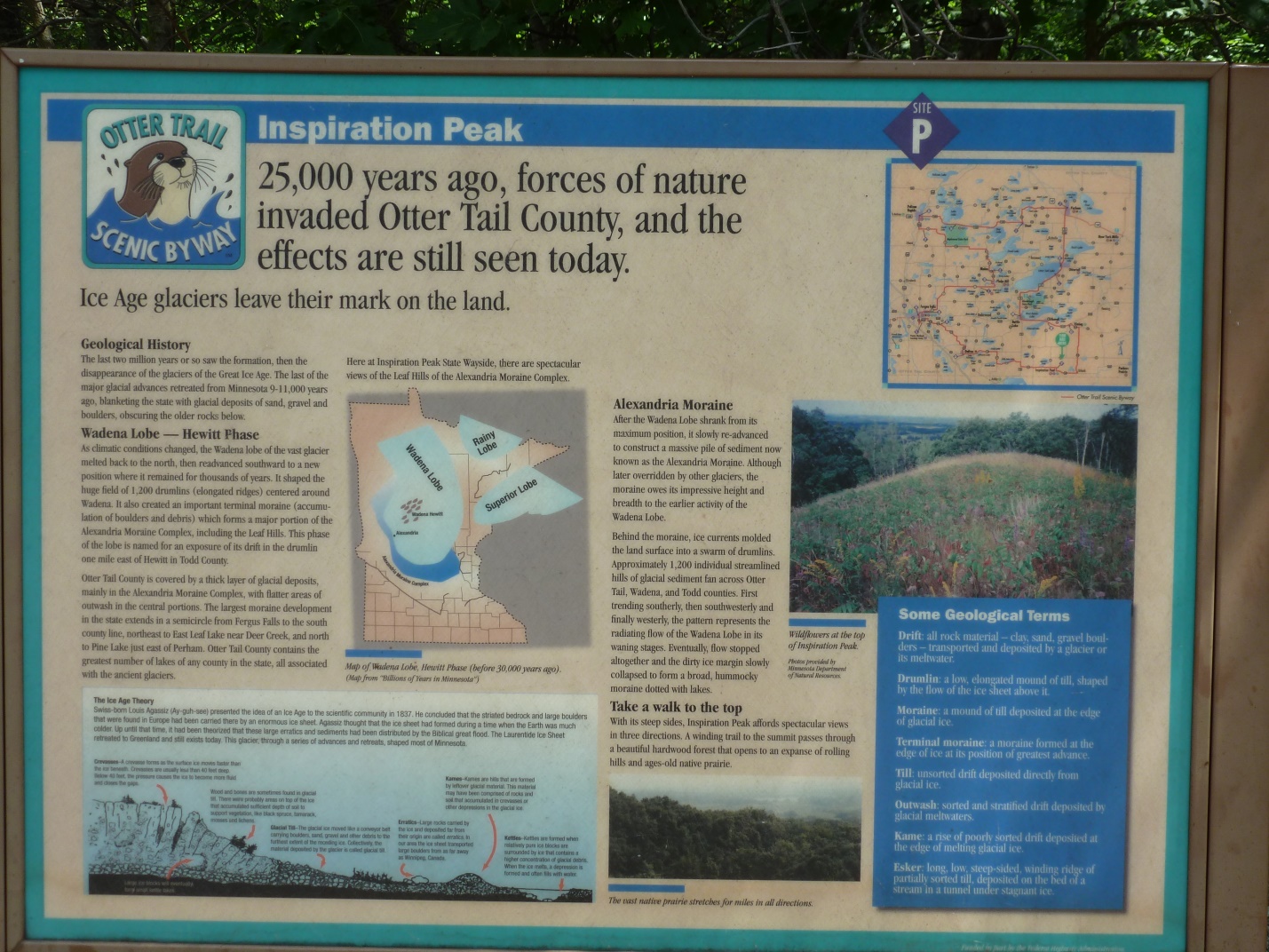
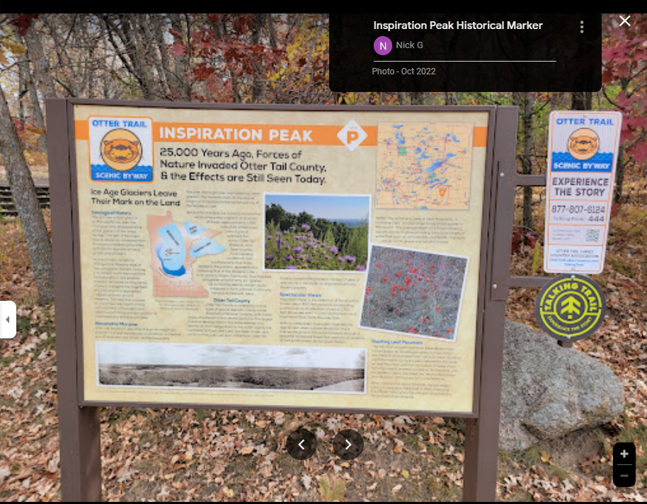
GEOLOGY OF INSPIRATION PEAK
At an elevation of 524 meters, Inspiration Peak stands high above the Leaf Hills portion of the Alexandria glacial moraine, affording a spectacular view of the surrounding area. The Alexandria moraine is an area of high hills that extends in a broad arc from western Becker County southeast to southern Stearns County in central Minnesota. The moraine consists of sediment (clay, silt, sand, gravel, and boulders) that was transported and deposited by glacial ice. About 25,000 years ago, glacial ice, which advanced into this area from the northeast, pushed up ice and existing sediment at its southwestern edge, forming the hills of the Alexandria moraine.
About 14,000 years ago, another lobe of ice, the Des Moines lobe, flowed southward from the Manitoba region. This ice lobe followed the lowlands of the Red River valley and the Minnesota River valley, finally reaching south into central Iowa near Des Moines. Occasionally, this lobe grew wide enough to advance eastward over parts of the Alexandria moraine. Locally, the Des Moines lobe reached as far east as Parkers Prairie, which is 18 kilometers east of here. The advancing Des Moines lobe reshaped the Leaf Hills by eroding the Alexandria moraine and redepositing the sediment. When the glacial ice receded, distinct topographic features, such as Inspiration Peak, were left behind.
Erected by the Geological Society of Minnesota in partnership with the Minnesota Department of Transportation, the Minnesota Geological Survey, and the Minnesota Department of Natural Resources. 2003
Region: North Central/West Region Date Updated: 6-12-25 Information Needed:
- Marker Images
Condition of Marker: Good Do it Yourself Region: Alexandria and Big Stone Verification: Patrick Steury
Enter Road Address in your cars GPS:
43749 120th St, Clitherall, MN 56524
OR
Enter Geographical Coordinates in your cars GPS:
Degrees Lat Long: 46.137776, -95.577875
Latitude: 46°08’11.2″N
Longitude: 95°34’33.3″W
Country: Otter Tail County
Where Found:
Marker is in Brandon, Minnesota, in Otter Tail County. Marker can be reached from 120th Street (County Highway 38) north of 435th Avenue when traveling east. Marker is located within Inspiration Peak State Wayside Park, near the north end of the parking lot, just north of 120th Avenue
Marker Number: 318
Marker Composition: High Pressure Laminate Signs
Text on Marker:
GEOLOGY OF INSPIRATION PEAK
At an elevation of 524 meters, Inspiration Peak stands high above the Leaf Hills portion of the Alexandria glacial moraine, affording a spectacular view of the surrounding area. The Alexandria moraine is an area of high hills that extends in a broad arc from western Becker County southeast to southern Stearns County in central Minnesota. The moraine consists of sediment (clay, silt, sand, gravel, and boulders) that was transported and deposited by glacial ice. About 25,000 years ago, glacial ice, which advanced into this area from the northeast, pushed up ice and existing sediment at its southwestern edge, forming the hills of the Alexandria moraine.
About 14,000 years ago, another lobe of ice, the Des Moines lobe, flowed southward from the Manitoba region. This ice lobe followed the lowlands of the Red River valley and the Minnesota River valley, finally reaching south into central Iowa near Des Moines. Occasionally, this lobe grew wide enough to advance eastward over parts of the Alexandria moraine. Locally, the Des Moines lobe reached as far east as Parkers Prairie, which is 18 kilometers east of here. The advancing Des Moines lobe reshaped the Leaf Hills by eroding the Alexandria moraine and redepositing the sediment. When the glacial ice receded, distinct topographic features, such as Inspiration Peak, were left behind.
Erected by the Geological Society of Minnesota in partnership with the Minnesota Department of Transportation, the Minnesota Geological Survey, and the Minnesota Department of Natural Resources. 2003
Region: North Central/West Region
Date Updated: 6-12-25 Information Needed:
- Marker Images
Condition of Marker: Good
Do it Yourself Region: Alexandria and Big Stone
Verification: Patrick Steury