Road Marker Views
Enter Road Address in your cars GPS: 95180 ANCHOR LAKE RD, EVELETH, MN 55734 OR Enter Geographical Coordinates in your cars GPS:
Degrees Lat Long: 47.319889, -92.470083
Latitude: 47°19’11.6″N
Longitude: 92°28’12.3″W
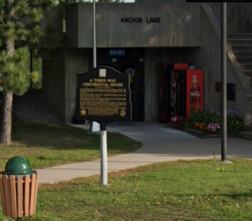
Located on U.S. highway 53 in Anchor Lake rest area.
Driving directions: From Interstate 35, get off at the Cloquet exit. Go north on Route 33. Route 33 turns into Route 53. About 5 miles south of Eveleth, drive into the Anchor Lake rest stop (east side of Route 53). Sign is located at the entrance to the restrooms.
Marker Number:251 Marker Composition: Cast Bronze on a post Text on Marker:
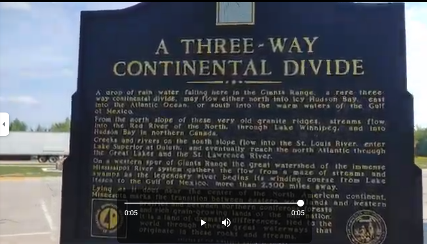
A THREE-WAY CONTINENTAL DIVIDE
A drop of rain water falling here in the Giants Range, a rare three-way continental divide, may flow either north into icy Hudson Bay, east into the Atlantic Ocean, or south into the warm waters of the Gulf of Mexico.
From the north slope of these very old granite ridges, streams flow into the Red River of the North, through Lake Winnipeg, and into Hudson Bay in northern Canada.
Creeks and rivers in the south slope flow into the St. Louis River, enter Lake Superior at Duluth and eventually reach the north Atlantic through the Great Lakes and the St. Lawrence River.
On a western spur of Giants Range the great water-shed of the immense Mississippi River system gathers the flow from a maze of streams and swamps as the legendary river begins its winding course from Lake Itasca to the Gulf of Mexico, more than 2,500 miles away.
Lying as it does near the center of the North American continent, Minnesota marks the transition between eastern woodlands and western prairies and between northern coniferous forests and rich grain-growing lands of the mid-nation. It is a land of dramatic differences, tied to the world through three great waterways that originate in these rocks and streams. 1993
Region: NORTH CENTRAL/WEST REGION Date Updated: 6-12-25 Information Needed:
- Marker Images
Condition of Marker: Fair Do it Yourself Region: IRON RANGE Verification: Patrick Steury
Enter Road Address in your cars GPS:
95180 ANCHOR LAKE RD, EVELETH, MN 55734
OR
Enter Geographical Coordinates in your cars GPS:
Degrees Lat Long: 47.319889, -92.470083
Latitude: 47°19’11.6″N
Longitude: 92°28’12.3″W
Country: Saint Louis County
Where Found:
Located on U.S. highway 53 in Anchor Lake rest area.
Driving directions: From Interstate 35, get off at the Cloquet exit. Go north on Route 33. Route 33 turns into Route 53. About 5 miles south of Eveleth, drive into the Anchor Lake rest stop (east side of Route 53). Sign is located at the entrance to the restrooms.
Marker Number: 251
Marker Composition: Cast Bronze on a post
Text on Marker:
A THREE-WAY CONTINENTAL DIVIDE
A drop of rain water falling here in the Giants Range, a rare three-way continental divide, may flow either north into icy Hudson Bay, east into the Atlantic Ocean, or south into the warm waters of the Gulf of Mexico.
From the north slope of these very old granite ridges, streams flow into the Red River of the North, through Lake Winnipeg, and into Hudson Bay in northern Canada.
Creeks and rivers in the south slope flow into the St. Louis River, enter Lake Superior at Duluth and eventually reach the north Atlantic through the Great Lakes and the St. Lawrence River.
On a western spur of Giants Range the great water-shed of the immense Mississippi River system gathers the flow from a maze of streams and swamps as the legendary river begins its winding course from Lake Itasca to the Gulf of Mexico, more than 2,500 miles away.
Lying as it does near the center of the North American continent, Minnesota marks the transition between eastern woodlands and western prairies and between northern coniferous forests and rich grain-growing lands of the mid-nation. It is a land of dramatic differences, tied to the world through three great waterways that originate in these rocks and streams. 1993
Region: NORTH CENTRAL/WEST REGION
Date Updated: 6-12-25 Information Needed:
- Marker Images
Condition of Marker: Fair
Do it Yourself Region: IRON RANGE
Verification: Patrick Steury