Skip to content
Geological Society of Minnesota

Geological Society

of Minnesota

  • Welcome Page
  • Road Markers
  • MembersExpand
    • Seminars and LabsExpand
      • Seminar/Lab Calendar
      • Current Year Schedule
      • All Seminars and Labs
      • Directions to Seminars and Labs
    • Fields TripsExpand
      • Field Trip Calendar
      • Help Field Trip Signup
      • Upcoming Field Trip
      • Field Trips Signup
      • Submit Field Trip Suggestions
      • Past Field Trips
      • Waiver of Liability
      • Waiver of Liability PDF
    • CalendarsExpand
      • Seminar/Lab Calendar
      • Field Trip Calendar
    • Member InformationExpand
      • Print a Membership Form
      • Enter in your membership form, then print
      • Membership application/renewal via credit card
      • Membership Help Document
    • Media LibraryExpand
      • Media Library Order/Display
      • Help Using Media Library
      • Suggested Geology YouTube Videos
    • GMS T Shirts and CapsExpand
      • Buy T Shirt and/or Cap
      • Help buying T Shirt/Cap
    • NewslettersExpand
      • Display Newsletters
      • NLs from the MN Geological SurveyExpand
        • Newsletter JPG Large
        • Newsletter JPG Small
      • Contributing to the Newsletter
  • Link
  • OutreachExpand
    • For Teacher
    • State FairExpand
      • State Fair Booth Rock Specimens List
  • AboutExpand
    • History
    • BoardExpand
      • Display Board Minutes
      • Board Information
      • GSM presidents
    • Organization InformationExpand
      • Articles of Incorporation
      • By_Laws
    • Mission
    • Administrator LoginExpand
      • Administrator Login Help
  • ContactExpand
    • Ask GSM
    • Ask ChatGPT a geology question
    • GSM USPS mailing address
  • Display PostsExpand
    • Display Blog Posts List
    • Display Blog Posts by Category
    • Help Viewing Blog Posts
Facebook Facebook
Search
Geological Society of Minnesota

Road Marker Information

Road Marker Information

Title: PORTSMOUTH MINE
Road Markers

Enter Road Address in your cars GPS:
23098 MN-6 Crosby, Minnesota

OR
Enter Geographical Coordinates in your cars GPS:

Degrees Lat Long  46.4909882,-93.9594986

Latitude:     46°29’29.3″N
Longitude:  93°57’26.9″W

Go to Google Map

Country: Crow Wing County
Where Found:

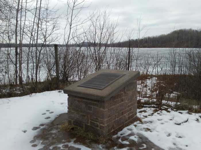
Located on State Highway 6 in a wayside 0.4 miles north of Crosby (overlooking Portsmouth Mine Pit Lake)

Marker Number:295
Marker Composition: Stone with Bronze plaques

Text on Marker:

PORTSMOUTH MINE

The Portsmouth was one of many iron and manganese mines that operated along the Cuyuna Range during the period 1911-1978. As much as 60 meters of glacial sediment cover the iron-bearing bedrock in this area; there are few natural rock exposures. Most ore deposits were discovered by magnetic surveys using a dip needle, which resembles a compass set on its side. During the 1890s, Cuyler Adams used this method to map much of the iron-formation. The name “Cuyuna” is derived from his first name, “Cuyler,” and the name of his canine assistant, “Una.”

At the Portsmouth Mine, about 13 million tons of iron and manganese ore were extracted from the slate, sandstone, and chert bedrock. These rocks were once clay, sand, and chemical precipitates that were deposited in an ocean about two billion years ago. They were subsequently buried deep in the earth where they were metamorphosed by heat and folded in a complex manner. The folding and associated fracturing provided pathways for fluids that precipitated the metal minerals and leached away silica. These processes concentrated the metals and created the high-grade ores, which have as much as 65 percent iron and 20 percent manganese.

The open-pit mining method used at the Portsmouth and other Cuyuna Range mines required the continual removal of water from the working pits, which could be more than 100 meters deep at some locations. When mining ceased, water slowly filled the pits, creating deep lakes with shorelines composed of glacial sediment. As a result, mine workings in the bedrock are no longer visible, and information about the rock is derived from the reports of mining geologists. The Cuyuna Range remains an important potential source of manganese, and mining may one day resume. The fact that one can barely see that a mine was here is a tribute to the effectiveness of mine-land reclamation practices and the natural growth of vegetation.

 Erected by the Geological Society of Minnesota in partnership with the Minnesota Department of Transportation and the Minnesota Geological Survey. 1998

Region: North Central/West Region

Date Updated: 20170305

Information Needed:

  1. Marker Images

Condition of Marker: Good
Do it Yourself Region: Brainerd-Mille Lacs
Verification: Bennyonbeacon@comcast.net

Members


  • Member Information
  • – Seminars and labs
  • Seminar/Lab Calendar
  • Current Year Schedule
  • All Seminar and Lab
  • Direction to Seminars and Labs
  • Field Trips
  • Field Trip Calendar
  • Upcoming Field Trips
  • Past Field Trips
  • Waiver of Liability
  • Waiver of Liability PDF
  • Video Library
  • GSM Video Library Display
  • Suggested YouTube Videos
  • GSM T Shirts and Caps
  • Add Clothing Item
  • Newsletter
  • Display Newsletters
  • Contribute to Newsletters
  • Board
  • Display Board Minutes
  • Board Information
  • Presidents of the GSM

Link/Outreach/About


  • Link
  • Outreach
  • For Teacher
  • State Fair
  • State Fair Booth Rock Specimens List
  • About
  • History
  • Organization Information
  • Articles of Incorporation
  • By Laws
  • Mission
  • Administrator Login

Contact/Display Post/ Road Markers


  • Contact
  • Ask GSM
  • Ask ChatGPT a geology question
  • GSM USPS Mailing Address
  • Post/Blog
  • Display Post
  • Display Post List
  • Road Markers
Facebook X Instagram

© 2025 Geological Society of Minnesota - WordPress Theme by Kadence WP

  • Welcome Page
  • Road Markers
  • Members
    • Seminars and Labs
      • Seminar/Lab Calendar
      • Current Year Schedule
      • All Seminars and Labs
      • Directions to Seminars and Labs
    • Fields Trips
      • Field Trip Calendar
      • Help Field Trip Signup
      • Upcoming Field Trip
      • Field Trips Signup
      • Submit Field Trip Suggestions
      • Past Field Trips
      • Waiver of Liability
      • Waiver of Liability PDF
    • Calendars
      • Seminar/Lab Calendar
      • Field Trip Calendar
    • Member Information
      • Print a Membership Form
      • Enter in your membership form, then print
      • Membership application/renewal via credit card
      • Membership Help Document
    • Media Library
      • Media Library Order/Display
      • Help Using Media Library
      • Suggested Geology YouTube Videos
    • GMS T Shirts and Caps
      • Buy T Shirt and/or Cap
      • Help buying T Shirt/Cap
    • Newsletters
      • Display Newsletters
      • NLs from the MN Geological Survey
        • Newsletter JPG Large
        • Newsletter JPG Small
      • Contributing to the Newsletter
  • Link
  • Outreach
    • For Teacher
    • State Fair
      • State Fair Booth Rock Specimens List
  • About
    • History
    • Board
      • Display Board Minutes
      • Board Information
      • GSM presidents
    • Organization Information
      • Articles of Incorporation
      • By_Laws
    • Mission
    • Administrator Login
      • Administrator Login Help
  • Contact
    • Ask GSM
    • Ask ChatGPT a geology question
    • GSM USPS mailing address
  • Display Posts
    • Display Blog Posts List
    • Display Blog Posts by Category
    • Help Viewing Blog Posts